

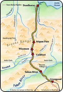
A trip along the Dalton Highway is an adventure that will take you on the only road in the United States to cross the Yukon River, Arctic Circle, and Brooks Range. Named for James William Dalton, a North Slope engineer, the Dalton was originally developed as a haul road connecting the Yukon River and Prudhoe Bay during construction of the Trans-Alaska Pipeline.

- Watch for signs of active gold mining near Livengood
- At first sight of the Yukon River, look for the Pipeline crossing the Yukon and Pump Station No. 6. The Dalton is the only highway in Alaska that crosses this great river.
- Seize a unique photo opportunity at the Arctic Circle BLM Wayside in front of the sign displaying N 66° 33'W 150° 48. In layman's terms, a place where the sun doesn't set on summer solstice and doesn't rise on winter solstice.
- Take five in the farthest North saloon in North America in Coldfoot.
- Temporarily increase the town of Wiseman's population with a stop at the Historical Museum (pop. 25).
- North of Wiseman, you will pass by Gates of Arctic National Park to the west and the Arctic National Wildlife Refuge to the east.
- Take advantage of the turnout at the summit of Atigun Pass. This Brooks Range pass is the highest pass in Alaska (4,800 feet).
- Look for Dall Sheep on Slope Mountain, gateway to the treeless coastal plain.
Caution: Road conditions vary. The Dalton Highway is mostly a gravel road with several steep grades. Extra supplies and spare tires are recommended. Best suited for travel June - August.

- ADF&G Wildlife Viewing Information
- Alaska Public Lands Information Center
907-456-0532
250 Cushman St., Suite IA
Fairbanks, AK 99701 - Arctic National Wildlife Refuge
800-362-4546
U.S. Fish & Wildlife Service
101 12th Avenue, Room 236, Box 20
Fairbanks, Alaska 99701
 arctic_refuge@fws.gov
 - BLM Visitor Guide to the Dalton
800-437-7021
Bureau of Land Management
1150 University Ave., Fairbanks, AK 99709 - Gates of the Arctic National Park
907-457-5752
201 First Avenue, Fairbanks, AK 99701
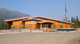
The Arctic Interagency Visitor Center in Coldfoot.
Credit: Lisa Shon Jodwalis, BLM
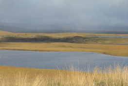
Dalton Highway shows off breathtaking vistas.
Credit: Aneta Synan, Alaska DOT&PF
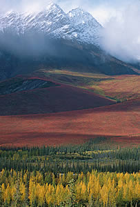
Fall foliage in the Brooks Range.
Credit: Dennis R. Green, BLM
Questions about the Scenic Byways web site? ![]() dot.scenic.byways@alaska.gov
dot.scenic.byways@alaska.gov
Scenic Byways List
- Alaska Marine Highway - Inside Passage
- Alaska Marine Highway - Gulf Coast Route
- Alaska Railroad
- Copper River Highway
- Dalton Highway
- Glenn Highway
- Haines Highway
- Kachemak Bay Route
- Parks Highway
- Prince of Wales Island Road System
- Richardson Highway - north segment
- Richardson Highway - south segment
- Seward Highway
- Steese Highway
- Sterling Highway - north segment
- Sterling Highway - south segment
- Taylor & Top of the World Highways
- Walden Point Road