
Angoon Airport Project SFAPT00086

Project Details
The need for a land-based airport
Angoon is located on Admiralty Island, and is accessible only by seaplane or ferry. It is the largest southeast Alaska community without an airport. Night landing is prohibited, and there are navigational hazards near the seaplane float area. At certain times of the year, prevailing northeasterly winds make landing difficult. Additionally, in the winter, Favorite Bay periodically ices up, precluding floatplane operations. The Alaska Marine Highway System typically provides ferry service to Angoon twice a week during late fall, winter, and early spring, and two to three times per week in the summer. The nearest commercial center (Sitka) is more than 5 hours away by ferry.
Due to Angoon’s remote location and limited transportation options, residents and businesses have difficulty accessing emergency health care, markets for its products, and necessary social, recreational, and educational opportunities. DOT&PF conducted several studies and determined that an airport that could accommodate Part 135 air carriers (scheduled commuter and unscheduled, on-demand charter carriers) and would provide medivac services as well as safe and reliable access to health care, goods, and services available in nearby developed areas.
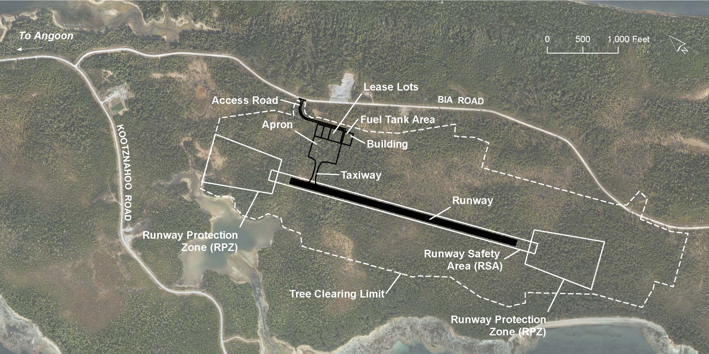
New airport features
The new airport will be a B-II facility, approximately the same size as the Kake Airport. It will be made up of 3,300-foot-long runway, a small paved apron, and a paved access road from the existing Bureau of Indian Affairs road. The runway is being designed to accommodate small passenger aircraft such as the Caravan and medevac aircraft such as the King Air 200 or Beechcraft 1900.
The airport will have non-precision instrument approaches and runway edge lighting. Lighting will allow aircraft to take off and land at nighttime. Each end of the runway will have a runway projection zone (RPZ). An RPZ is a cleared, restricted-use area that serves as a buffer zone for approaching/departing aircraft.
There will be a wildlife perimeter fence around the airport built to USDA specifications.
If it is affected by the airport project, the trail access to Hood Bay will be re-routed. Eventually, the runway will be expanded to 4,000 feet. This project will acquire needed ROW to accommodate future development.
Once construction is complete, DOT&PF will contract with a local group to maintain the airport. DOT&PF will pay for all maintenance costs.
Recent Work
2021 and 2022: The airport project is in the ROW phase.
April 2020: The Federal Aviation Administration (FAA) has approved the Airport Layout Plan (ALP). This important decision document identifies airport boundaries, the location of access roads, the runway and taxiways, the apron, and other proposed facilities, and prominent features like the stream culvert under the runway and related drainage structures. The ALP is available online (8MB file).
The ALP provides the basis for determination of properties impacted by airport construction and operation. Right-of way (ROW) work is underway to identify property owners and the property appraisal effort has begun. In the coming months, the Alaska Department of Transportation and Public Facilities (DOT&PF) and the Angoon Airport Project Team will directly contact all owners of properties affected by the project. See more about the ROW process.
The ALP was also required for finalizing the Environmental Impact Statement (EIS) reevaluation. This document outlines changes to the original environmental analysis and supports the permitting process. The FAA-approved EIS revaluation is available online. Hard copies are available at Juneau city libraries, the City of Angoon, and the Angoon Community Association.
December 2019: Public information session held in Angoon.
September 2019: Geotechnical work.
Additional geotechnical investigations at the future airport site were conducted September 16-20. The team dug approximately 15 additional test pits. Findings will support the design of the proposed fish passage culvert, stream realignment, and surcharge embankments.
January/February 2018: Planned public meeting to discuss layout of airport on the site.
2017: The engineering team was studying the site and refining the design for the airport at the location selected by FAA. This included:
- Geotechnical studies continue to determine ground softness/hardness, and to find areas best suited to support construction.
- Hydrologic studies to determine the amount of water at the site and to plan for dealing with it.
- Surveys to map out the terrain and determine the best layout for the airport runway and apron.
- Survey to evaluate the proximity of nearby mountains and the effect on aircraft approaches.
- Studies to determine impacts to right-of-way and wetlands and what acquisitions and permits may be needed.
October 2017: Public meeting held in Angoon.
Summer 2017: Geotechnical studies were started to determine ground softness/hardness, and suitability for airport construction.
2016: The FAA completed a Final Environmental Impact Statement and signed a Record of Decision in October 2016 that selected Alternative 12a for the Angoon Airport. See the Documents page for more details.
For more project details, visit the Frequently Asked Questions page.
Questions? See the project Contacts page.
Project Information
- Angoon Airport Project Home
- Project Details
- Project Schedule
- Right-of-Way
- Public Involvement
- FAQs
- Documents
- Comment
- Contact Us